Urban 3D Buildings: Transforming Digital Design, Planning, and Creative Expression
What Are Urban 3D Buildings?
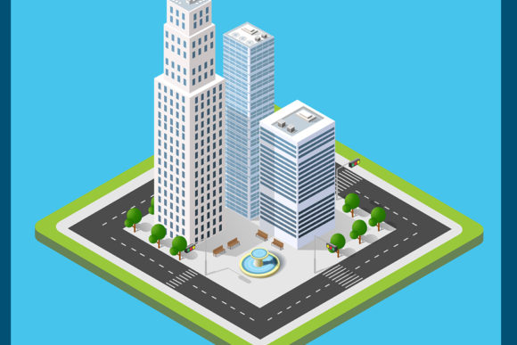
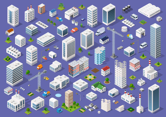
Urban 3D buildings refer to digitally modeled, three-dimensional representations of structures—such as skyscrapers, apartment complexes, transit hubs, and mixed-use developments—within a cohesive cityscape. Unlike isolated architectural models, urban 3D buildings are designed to exist in context: scaled accurately, georeferenced to real-world locations, and integrated with surrounding infrastructure like roads, parks, and utilities. These models range from stylized visualizations for public engagement to highly precise, data-rich assets used in engineering simulations and smart city platforms.
Why Do They Matter Today?
In an era defined by rapid urbanization, climate resilience, and digital transformation, urban 3D buildings have evolved from niche visualization tools into foundational elements across multiple disciplines. By 2050, nearly 70% of the global population is projected to live in cities—a reality demanding smarter planning, more responsive infrastructure, and inclusive design processes. Urban 3D buildings serve as both a mirror and a blueprint: they reflect how cities currently function while enabling stakeholders to test ideas—like pedestrian flow during rush hour or solar gain on façades—before breaking ground.
Real-World Applications Across Sectors
- Urban Planning & Municipal Government: City planners use interactive 3D city models to assess zoning compliance, shadow impact, wind patterns, and emergency evacuation routes. For example, Singapore’s Virtual Singapore platform integrates real-time sensor data with high-fidelity 3D building models to simulate flood scenarios and optimize traffic light timing.
- Architecture & Construction: Firms leverage urban 3D buildings in early-stage massing studies to evaluate contextual fit—how a proposed tower relates to skyline rhythm, street-level scale, and historic landmarks. BIM (Building Information Modeling) workflows now extend beyond single structures to include neighborhood-level coordination, reducing costly clashes during construction.
- Real Estate & Marketing: Developers deploy immersive 3D city tours to showcase off-plan properties. Buyers can navigate virtual neighborhoods, check sightlines from balconies, or even toggle seasonal lighting—building confidence before committing to high-value purchases.
- Education & Public Engagement: Schools use simplified urban 3D environments to teach geography, sustainability, and civic literacy. Community workshops invite residents to explore “what if?” scenarios—such as converting a parking lot into green space—using intuitive drag-and-drop interfaces.
- Gaming, Film & Metaverse Experiences: From Grand Theft Auto’s stylized Los Santos to photorealistic recreations of Tokyo in VR art installations, urban 3D buildings fuel narrative depth and spatial authenticity. Their increasing accessibility means indie creators now build rich cityscapes using open-source tools like Blender and CesiumJS.
How Are Urban 3D Buildings Created?
Creating accurate urban 3D buildings involves a blend of automation, surveying, and expert refinement. The process typically follows these stages:
- Data Acquisition: Sources include LiDAR scans, satellite imagery, drone photogrammetry, GIS databases (e.g., OpenStreetMap), and municipal building footprints. High-resolution elevation models ensure correct terrain integration.
- Base Modeling: Automated tools generate initial geometry—extruding footprints into 3D volumes based on height attributes. This “first pass” is fast but often lacks architectural nuance.
- Detailing & Styling: Artists and modelers add façade textures, window patterns, roof forms, signage, and environmental context (e.g., trees, benches, streetlights). Style choices vary: photorealistic for developer presentations, abstract for conceptual planning, or low-poly for real-time web applications.
- Integration & Interoperability: Models are optimized for performance and exported in formats like glTF (for web), IFC (for BIM), or CityGML (for GIS analysis). Semantic tagging—labeling a building as “hospital,” “school,” or “residential”—enables intelligent querying and simulation.
Common Misconceptions—Clarified
Many assume urban 3D buildings are merely “fancy graphics.” In truth, their value lies not in visual polish alone—but in structured data. A well-built model contains metadata about energy performance, material composition, occupancy type, and even maintenance schedules. Another misconception is that only large cities or wealthy governments can afford them. Thanks to open data initiatives, cloud-based modeling platforms, and AI-assisted generation tools, mid-sized towns and community groups now create functional urban 3D sets—for under $5,000 and in under six weeks.
The Technology Behind the Scenes
Advancements in several intersecting fields have accelerated adoption:
- AI & Procedural Generation: Tools like Esri’s CityEngine use rule-based systems to auto-generate thousands of context-aware buildings from simple parameters—saving months of manual labor without sacrificing design logic.
- WebGL & Real-Time Rendering: Modern browsers now render complex urban scenes smoothly via WebGL and WebGPU. Platforms like Cesium ion let users stream globally scaled 3D cities directly in Chrome or Safari—no plugins required.
- Digital Twins: Urban 3D buildings form the spatial backbone of digital twins: living replicas synchronized with IoT sensors, weather feeds, and transportation APIs. These twins help cities reduce energy use, improve air quality monitoring, and respond faster to disruptions.
Practical Benefits You Can Experience
You don’t need to be a city planner or developer to benefit. Consider these everyday advantages:
- Travel Planning: Apps like Google Maps now incorporate 3D building layers to help orient travelers—even indoors—reducing confusion when navigating unfamiliar districts.
- Home Renovation: Before installing solar panels, homeowners can upload their address into tools like Aurora Solar to see how nearby 3D buildings cast shadows across their roof throughout the year.
- Educational Projects: Students in geography class might compare 3D models of Paris and Mumbai to analyze density, green space access, or informal settlement patterns—developing critical spatial reasoning skills.
- Creative Exploration: Artists use free datasets (e.g., NYC’s NYC3D) to remix cityscapes in generative art projects, highlighting themes like gentrification, mobility equity, or climate vulnerability.
Getting Started—No Technical Degree Required
Curious but unsure where to begin? Start small—and stay practical:
- Explore freely available models: Visit Brooklyn’s 3D Map, Chicago’s 3D City Model, or OpenStreetMap’s 3D layers.
- Try beginner-friendly tools: SketchUp Free offers intuitive urban modeling; QGIS + Qgis2threejs lets you convert 2D maps into shareable 3D scenes.
- Join communities: Forums like the CityGML Community or Reddit’s r/urbanism welcome questions, tutorials, and collaborative feedback.
Looking Ahead: Ethics, Equity, and Evolution
As urban 3D building use expands, so do important questions. Who owns the data? How do we prevent surveillance creep when every lamppost and façade is digitized? And crucially—how do we ensure these tools serve *all* residents, not just developers or tech firms? Forward-thinking cities are adopting participatory 3D modeling, where community members co-create models using mobile apps and local knowledge—capturing informal economies, cultural landmarks, and lived experiences often missing from official datasets.
Urban 3D buildings are more than pixels and polygons. They’re evolving interfaces between people, policy, and place—bridging imagination and implementation, data and democracy, code and culture. Whether you’re sketching a neighborhood park redesign, analyzing transit equity, or simply wondering how your city might adapt to sea-level rise, these digital foundations offer clarity, connection, and creative possibility—one building at a time.